
Data Processing & Production
Point Clouds
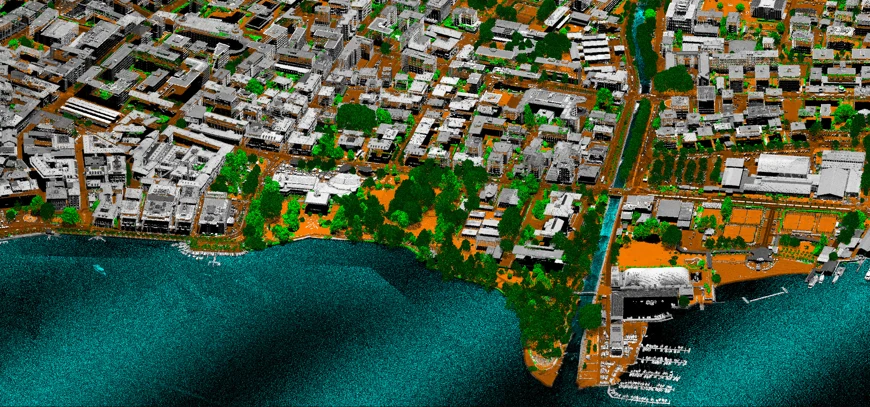
Georeferenced point-cloud products from airborne mapping, UAV mapping, mobile mapping, bathymetric survey and handheld / terrestrial 3D capture — processed to the density, accuracy, classification level and delivery speed required by the project.
around 1 to several hundred points/m²Typical delivery density rangeRange varies by acquisition source and intended use.
What we do
Point clouds built for the next task
MapSoft produces georeferenced, aligned, colourized and classified point clouds from airborne, UAV, mobile, bathymetric and handheld mapping. Density, accuracy, classification and processing depth are configured around the intended use — from terrain modelling and engineering extraction to 3D modelling, asset documentation and GIS/BIM workflows.
Where early access matters, georeferenced datasets can be prepared soon after acquisition and refined in later production stages. Final delivery can range from around one point per square metre to several hundred points per square metre, with project-specific QA/QC matched to the required reliability.
Where it is used
Built around the project context.
Engineering and infrastructure mapping
Building and 3D modelling
Riverbank and riverbed integration
Vegetation / ground separation
GIS/BIM-ready spatial foundations
Delivery profiles
The method and product level follow the intended use.
Rapid availability
Where early access is important, georeferenced point clouds can be prepared quickly after survey missions for initial review, planning or parallel engineering work, followed by deeper classification and validation as required.
Rigorous final QA/QC
Final production datasets can include project-specific classification, manual correction, consistency checks between passes or sensors, completeness verification and documented control against independent measurements.
Options
Acquisition sources
Projects
All matching projects→Capability proven through realized work.
 Geospatial
Danube & Sava River Mapping
Large-scale multisensor river mapping integrating airborne LiDAR, vessel-based mobile mapping, UAV mapping and multibeam bathymetry into a seamless engineering-ready geospatial foundation for navigation, hydraulic and morphological analysis.
661 kmRiver channels surveyed
View project → Geospatial
Geospatial Baseline for Nuclear Site Investigation in Thrace, Türkiye
A secure, large-area airborne LiDAR and aerial-imaging campaign producing a quality-controlled terrain and imagery baseline for technical investigation of a strategic energy site in Thrace.
2,000 km²Approximate survey area
View project → Geospatial
Prijepolje Archaeological LiDAR — UAV Mapping & Interpretation of Four Sites
A high-density UAV LiDAR and RGB project across four archaeological sites, producing classified point clouds, 2 cm orthophotos, 10 cm terrain models and confidence-qualified interpretation vectors.
4 sitesArchaeological sites
View project → Geospatial
CIRC-BOOST Belgrade — 3D Building Survey for Circular-Construction Research
A high-resolution urban 3D survey combining UAV and mobile LiDAR, GNSS control, point-cloud processing and CityGML LoD2 modelling to create a validated spatial foundation for circular-construction and building-stock research.
38 missionsUAV flight missions
View project → Integrated
Herceg Novi Geospatial Data & Solar Potential Geoportal
A two-phase municipal programme connecting city-scale airborne LiDAR and four-band aerial imagery, structured roof/building solar-potential data and real browser-based 2D/3D Geoportal interfaces.
3,484 haFinal survey footprint
View project →MapSoft
Talk to our team→